Mt. McKinley

Saturday, July 13, 2013
New "Milepost Alaska Highway Geology" blog
See my new blog at http://fanrgs.blog.com. I have had to continue my Milepost Alaska Highway Geology blog on a new site because I was not able to post on this site for a week due to technical difficulties and no response from Google to my problem.
Friday, June 28, 2013
Milepost “Central Access Route”:
.jpg)
E157.6:
At Omak, we entered the exotic terrane called the Okanogan Trench, the old
subduction zone at the edge of the North American Plate plate (see my June 10
post on Amchitka Island and the Aleutian Trench).
.jpg)
.jpg)
E171 – E181 (north of Riverside, south of Tonasket): Look west of US 97 at the
base of the hills. Do you see a valley
(depression) that is lower than the road and looks like it should carry a
stream, but there is no stream? There
are a couple of small lakes at the bottom of the deeper parts of the
depression—Booher Lake and Crumbacker Lake—but nothing that could have carved
such a deep valley. That valley is an
old river channel, now dry, that was carved by glacial meltwater at the end of
the last ice age about 14,000 years ago (see my May 27 post). This channel will probably remain dry until
the next ice age!

E197 - E315: A series of natural glacial lakes filling the bottom of the Okanogan
Trench begins at Oroville, WA and ends at Vernon, BC, a road distance of 120
miles. The lakes, from south to north,
are Osoyoos Lake, Vaseux Lake, Skaha Lake, the big one—Okanagan Lake, and
Kalamalka Lake. These remnants of the
last ice age provide substantial quantities of irrgation water for the
intensive fruit and wine growing industry of the Okanagan Valley.

E237.9:
Other remnants of the ice age are less obvious than the huge lakes of the
Okanagan Valley. From the overlook of
Skaha Lake just before entering the city of Penticton, there is a view of two
of those remnants. In the photo below
is a grass-covered, light-colored, nearly vertical bluff rising from the
lake. This bluff is composed of silt
and clay deposited in Glacial Lake Okanagan, which once filled the entire
valley with significantly more water than exists today in all five lakes.


E323 - E360: Highway 97 follows a valley that formed along another fault system called
the Bolean Creek Fault. This fault
divides two very different geologic provinces—with metamorphic rocks to the
northeast of the highway and sedimentary and volcanic rocks to the
southwest. Interestingly, both rock
types weather into rounded hills and long ridges and both are nearly completely
covered by conifer forest, so little geology is visible to a 55-mph traveler
through this area. The valley, however, is also a geologic feature because it follows the weak zones created by the fault. Movement of faults form "shear zones" of broken-up rock rubble that are more easily eroded by streams than the surrounding rocks. So, the streams and rivers follow those shear zones, sometimes in a very straight line, and geologists use stream patterns to locate those faults. They also use stream patterns to identify certain rock types and geologic structures.

We’re here! We have finally arrived
on the “Central Access Route” approach to the Alaska Highway. However, we didn’t get on it at Mile “0” at
Ellensburg, but at Omak via WA 155 after visiting Grand Coulee Dam. So, I can’t really comment much on the
geology farther south, but even beginning at Milepost E157.6 and following the
access route only to Kamloops at Milepost E386 provides an amazing journey into
an “exotic terrane.”
We drove across a granite batholith called the Okanogan Dome from Grand
Coulee Dam, The granite dome is a
melted portion of a “subcontinent” (larger than an island arc) that migrated by
continental drift and hit the North American Plate just before it melted 50
million years ago. The photo below
shows an pale gray outcrop of the granite of the dome.
.jpg)
The photo below was taken from WA 155 just east of Omak, looking west
across the Okanogan Valley. I am
standing on the rocks of the Okanogan Dome, looking down into the trench and
across to the mountains of the Cascade Subcontinent on the west side of the
valley. Millions of years ago, these
three zones of the Okanogan Trench were separated by thousands of miles of
Pacific Ocean.
.jpg)
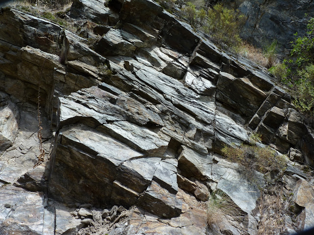
E159 - E180: The Okanogan Dome is surrounded by one-time sedimentary rocks of the
subcontinent that were metamorphosed by heat from the melted granite below
them. As the dome rose, the metamorphic
rocks were tilted upward around it. In
the photo below, the angled rocks are located east of US 97 and dipping
(sloping) westward into the Okanogan Trench.
.jpg)
The photo below shows the dry channel west of US 97/WA 20 and the present
course of the Okanogan River east of the highway. It also shows the short distance across the Okanogan Trench on
the U.S. side of the border.

E231.2:
Photo taken at Christie Memorial Provincial Park day-use area on in Okanagan
Falls showing Hwy. 97 climbing into the bedrock on the west side of Skaha
Lake. This dark gray, white-banded
gneiss is part of a subcontinent that “docked” with the NA Plate about 50
million years ago.

Above and to the left of the bluff are several dark gray, rounded rock
outcrops. And, if you look to the right
above those three outcrops, you can see a number of other smaller, similarly
shaped outcrops. These rounded features
are called “roche mountonnees,” a French term meaning “sheep rocks.” On all of these outcrops, there is a smooth,
gently sloping side on the left and a steeper, more angular side to the
right. These features can be used to
determine the direction of movement of a glacier, with the smooth side ground
down more by the glacier moving across it from left to right.

E290 - E320: Highway 97 barely fits into the bench along the east side of Okanagan
Lake. The slopes above the road are
steep because the road is built almost on top of the Okagangan Valley Fault, a
system of normal faults that run the entire length of the Okanagan Valley. Near Vaseux Lake in the southern end of the
valley, the faults dip (slopes) only about 10 degrees to the west. North of Kelowna, however, the faults become
much steeper before veering off to the northeast north of Vernon. The photo shows the northern end of the
fault along Kalamalka Lake just before it leaves Highway 97.

E370 - E386: Highway 97 joins Trans-Canada Highway 1 at E369.5 and follows the South
Thompson River Valley into Kamloops.
The most noticeable geologic feature of this portion of the highway is a
light-colored bench running the entire distance (photo below). This is “lucustrine silt,” the rock flour
created by the glaciers in the mountains to the north and east washed into
Glacial Lake Thompson. The ice dam that
created this lake was located in the area of today’s Kamloops Lake on the
Thompson River east of Kamloops. The
silt settled to the bottom of this huge lake after each year’s spring runoff,
forming layers called “varves.” The
thickness of this silt is estimated at nearly 1,000 feet and, some geologists
believe, may have been deposited in no more than 100 years!

Wednesday, June 26, 2013
Mile-High Ice Dams, Glacial Superlakes, Prehistoric Megafloods, and "Grand Coulees"
What happens to an ice cube when you drop it into a glass of water? That’s easy! It floats to the top, right? What happens when you pond several rivers behind an ice dam half a mile high? If the water gets deep enough behind the dam, the ice will float, right?
.jpg)

.jpg)

What happens to an ice cube when you drop it into a glass of water? That’s easy! It floats to the top, right? What happens when you pond several rivers behind an ice dam half a mile high? If the water gets deep enough behind the dam, the ice will float, right?
Now you have a picture of what happened in eastern Washington many times
during the Pleistocene ice ages.
Geologists have estimated at least 41 separate gigantic floods, the
world’s largest ever, rushed across the Columbia Plateau Basalts of eastern
Washington when the ice dam broke. The
continental glacier in British Columbia was called the Cordilleran Ice Sheet,
which continued to push lobes of ice across Washington, Idaho, and Montana
throughout this period. These lobes
pushed the Columbia River south to its present channel. When the river channels were blocked, the
lake backed up behind each ice lobe was called Lake Missoula. This lake filled the entire valleys of Coeur
d’Alene Lake, Lake Pend Oreille, and Flathead Lake. The floods that occurred each time the ice lobe floated were
called the Spokane Floods.
When each dam broke, these immense floods were apparently as much as 600
feet deep at places like Spokane and Lewiston, Idaho, for days at a time. The amount of erosion that can be caused by
a 600-foot high wall of water is simply unfathomable in today’s world. Where the floods were confined, they dug
deep channels, called “coulees,” into the basalt that are now dry. My June 25 photo below shows Grand Coulee,
which now carries the Columbia River, but which was originally carved into the
Columbia Plateau Basalts and underlying granite by the Spokane Floods.
.jpg)
Where the flood waters spread out, they scoured all of the soil, loess
(windblown silt), loose rock, and vegetation off vast areas of the basalt lava
flow, leaving hils and valleys of exposed basalt. These stripped areas can be seen along US 2 just east of the town
of Creston and along I-90 between Sprague and Four Lakes. The following satellite image shows the huge
scoured areas that are now called the “channeled scablands.”

However, these floods were not merely destructive, they were also
constructive. When the flood waters
receeded, they left behind enormous volumes of gravel, sand, and silt. The next photo shows some nearly level sand
and gravel terraces as much as 200-feet high formed by receeding Spokane
floodwater in Grand Coulee. Each
terrace represents one recession event, with successive floods partially
eroding the last terrace and redpositing that material downstream.
.jpg)
Another type of depostion in northern Idaho and eastern Washington during
the ice ages was not a product of the Spokane Floods, but of winds. The amount of basalt rock ground up into
rock flour by the glaciers during the ice ages was immense. As the glaciers receeded, this silt-sizes
material was picked up by the wind and deposited in “dust dunes.” After the ice ages, these gently rolling
hills were vegetated by grasses, but few trees that we now call the
“Palouse.” Today, these hills form some
of the richest wheat-farming regions of the world. The photo below shows an example of Palouse terrain along US 2
near Creston, WA.

Next time: We finally meet our Milepost
“Central Approach Route” to the Alaska Highway with a discussion of the
geology of the “exotic terrane” along US/BC 97 in the Okanogan-Okanagan valley.
Monday, June 24, 2013
Anyone for a South Pacific vacation after your Alaska Highway trip? You can view some South Pacific geology in
west-central Idaho on your way home!
.jpg)
.jpg)
.jpg)
.jpg)
As we drove north down the Little Clearwater River from our pine-forested
lunch stop near Pinehurst, Idaho, we came around a curve and the vegetation
changed completely. The change was so
abrupt that my wife commented that it looked like “it must rain a lot less
here.” But how could that happen in
such a short distance?
The answer was that it couldn’t, so, having read about the area before our
trip, I responded that it wasn’t the precipitation that changed, but the
geology. When we came around that
curve, the pine-forested slopes of granite and basalt that we had been driving
through became barely vegetated cliffs of metamorphic rock. We had gone from the granite of the Idaho
Batholith and Columbia Plateau Basalts into the Seven Devils complex. To put it in terms discussed in the June 2
post, we had entered one of those “exotic terranes” where an island arc crashed
into the North American Plate.
Geologists have dated the “crash” at about 90-100 million years ago (the
Cretaceous Period, when some of the last dinosaurs, like the duck-bill
dinosaurs and T. Rex, were walking around).
However, the rocks of the island arc were as much as 250 million years
old (Permian and Triassic-age) and were formed in the warm waters of the South
Pacific. The very large, tough, granitic Idaho Batholith was the western edge
of the NA Plate, so the “softer” sedimentary rocks of the island arc simply
smashed into an “immovable object” and were partly subducted and partly crushed
(metamorphosed) into a thick sequence of gneiss and schist. The partially subducted rocks are called the
Seven Devils Complex and the highly metamorphosed rocks are called the Riggins
Complex.
The following photo shows the Seven Devils Complex dipping (sloping) down
toward the east (as if to dive under the Idaho Batholith granites of the NA
Plate). You can easily see how little
vegetation there is in this exotic "terrane,” a sharp contrast to the conifer
forest of the area just to the south along US 95.
.jpg)
The photo below shows the southwestward-dipping rocks of the Riggins
Complex along the west bank of the Salmon River, just downstream from the
whitewater-rafting mecca of Riggins, ID.
The Riggins Complex rocks apparently hit the edge of the Idaho Batholith
and were bent upward, while the rocks of the Seven Devils Complex were forced
under the Riggins rocks. Notice the
dip-controlled surface topography above the cliff (the sun-baked, smooth,
grassy slope at the upper left). That
is Columbia Plateau Basalt overlying the Riggins Complex. And why is the basalt dipping southwest
too? It is due to “isostasy,” the
removal of the overlying weight of the rocks by the erosion by the Salmon
River. This “unloading” results in the
underlying fluid mantle pushing the overlying continental crust up as the load
is reduced (see my May 31 post about marshmallows and hot cocoa). The same thing is still
happening in the Midwest and Canada due to the removal of the ice load in the
14,000 years since the Wisconsin glaciation ended.
.jpg)
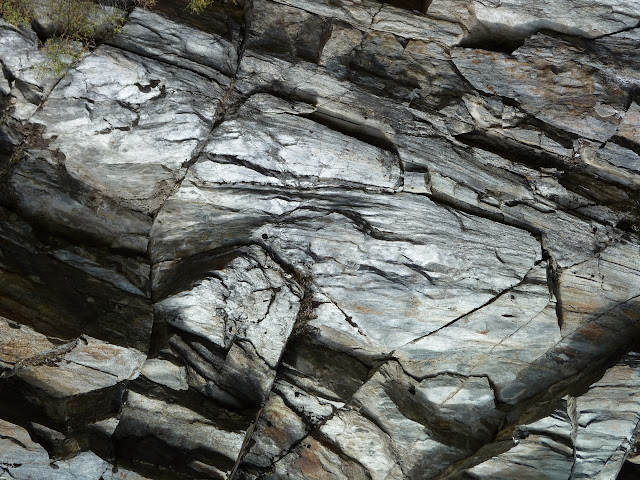
Below is a photo of a blocky, fractured outcrop of metamorphic rocks of the
Riggins Complex north of the town of Riggins.
It would be very difficult to tell whether these mica schists were
originally sedimentary or igneous rocks when they were deposited in the South
Pacific Ocean 250 million years ago.
.jpg)
The photo below is a close-up of the same outcrop of Riggins Complex
schists. Note the way the sunshine on
the rocks gives them a “sheen” caused by the planar alignment of the flat mica
sheets that make up the schist.
.jpg)
After climbing a very long hill on US 95 northwest of White Bird, ID, we
encountered another abrupt change from the rocks of the island arc back into
the Columbia Plateau Basalts. It will
be interesting to see if the island arc terranes of the Okanagan Valley of
central Washington and southern British Columbia have as abrupt contacts with
the surrounding rocks as those of Idaho.
And now, if you happen to be driving home from Alaska via US 95 from Coeur
d’Alene to Boise, you will know exactly when you leave North America and enter
the “South Pacific”!
Next time: Glaciation in the Coeur d’Alene to Grand Coulee region has immensely
modified the Columbia Plateau basalt surface in east-central Washington State.
Sunday, June 23, 2013
Craters of the Moon is an otherworldly experience. For a geologist, walking up a 2,000 year-old volcanic cinder cone
with not one plant growing on its sides is like climbing a staircase built last
week for a non-geologist. Time measured
in human terms is so recent that all of human existence would literally be the
thickness of a hair lying on top of a yardstick standing on end, where the
yardstick represented the rest of geologic time. So, a geologic event that occurred within the oral history of a
people that still exist in southern Idaho, like the Shoshone-Bannock tribes, is
not yesterday, but last second, in geologic time.
.jpg)
The second photo shows a sloping pahoehoe flow with no vegetation after 2,000 years. “Pahoehoe” is a Hawaiian word for a “rope-like” flow that forms a smooth skin as it cools, sort of like the skin that forms on a bowl of chocolate pudding after it has cooled. The smooth skin only forms on cooling lava that contains a considerable amount of gas or water vapor.
.jpg)
.jpg)
As it travels farther from its source and begins cooling, the gases begin
to be lost and the lava becomes thicker and more brittle. Instead of stream of flowing lava, the front
of the flow becomes a tumbling mass of jagged pieces of lava containing many
tiny voids where gas bubbles get trapped.
This is called “a’a” lava in Hawaiian.
The photo below is of an a’a flow that is just beginning to support plant
life after 2,000 years! The weathering
and erosion process for lava flows in land-locked, semi-arid southern Idaho is
very different from the same geologic processes on the humid Big Island of
Hawaii surrounded by the Pacific Ocean.
.jpg)
Craters is an area of not just cinder cones, but both pahoehoe and a'a
volcanic flows, spatter cones, lava tubes, and tree trunk molds. These features are not large, like the Grand
Canyon, or spectacularly colored, like Bryce or Zion, but resemble features on
the Big Island of Hawaii than like other national monuments in the U.S.
The first photo shows a small spatter cone, a feature built up by small
blobs of red-hot lava being ejected from a nearly stationary flow by escaping
gas or steam. This cone is formed from
a’a lava, the jagged, broken type of lava flow that is nearly impossible to walk
across.
.jpg)
The second photo shows a sloping pahoehoe flow with no vegetation after 2,000 years. “Pahoehoe” is a Hawaiian word for a “rope-like” flow that forms a smooth skin as it cools, sort of like the skin that forms on a bowl of chocolate pudding after it has cooled. The smooth skin only forms on cooling lava that contains a considerable amount of gas or water vapor.
.jpg)
The photo below shows the Indian Tunnel lava tube that formed when molten
pahoehoe lava continued to flow under a cooling skin until the source finally
stopped producing lava and the cooling tube emptied. This tube is 30 feet high, 50 feet wide, and 800 feet long, but
several portions of the roof have collapsed, as can be seen by the “skylights” and
rubble in the photo. This tube got its
name because of evidence that Native Americans used the tube for temporary
habitation.
.jpg)
.jpg)
Saturday, June 22, 2013
We’re finally on the road to Alaska!
We spent the first night at Flaming Gorge Reservoir in northeastern
Utah. The Uinta Mountains are one of
the very few east-west trending mountain ranges in the Lower 48. Geologist-explorer John Wesley Powell led
the first expedition through this gorge in May of 1869, the same month the
first transcontinental railroad was completed at Promontory Point, Utah. Powell named this gorge for the “flaming”
red rock formations towering above him as he floated down the Green River (see
photo). He also developed his theory of "superposition" to understand why the Green River would flow across the hard Precambrian rocks in the core of the Unitas instead of around the range. Today Utah provides great road
signs along US 191 that identify each of these formations as you are driving up
into the mountains, but down in geologic time.
From south to north, the highway runs from the Eocene Green River
Formation (50 million years old) to the PreCambrian Uinta Formation (800
million years old).

From the Uinta Mountains, we crossed the desolate Green River Basin to the rugged Wind River Mountains. Near the town of Pinedale is a 14,000 year-old terminal moraine that is famous to North American glacial geologists. This moraine marks the greatest extent of the last advance of mountain glaciers in the Rocky Mountains, so this glacial time period is named the “Pinedale.” In the U.S. Midwest and Canada, this same glacial period is called the “Wisconsin.”
.jpg)

From the Uinta Mountains, we crossed the desolate Green River Basin to the rugged Wind River Mountains. Near the town of Pinedale is a 14,000 year-old terminal moraine that is famous to North American glacial geologists. This moraine marks the greatest extent of the last advance of mountain glaciers in the Rocky Mountains, so this glacial time period is named the “Pinedale.” In the U.S. Midwest and Canada, this same glacial period is called the “Wisconsin.”
Northwest of the Wind River Mountains is another northwest-trending range
called the Gros Ventre Range. The Gros
Ventres are at the eastermnost front of the Wyoming Overthrust Belt, a
north-south trending series of “thrust faults.” Unlike strike-slip faults, thrust faults have nearly flat-lying
or low-angle fault planes that resemble a new deck of playing cards. If you split the deck in half and turn the
two halves face up, you can see the cards in each half. Place one half against a wall and push the
other half against the first half. Some
of the slick second-half cards slide across the top of the stationary half and
others slide between the stationary cards.
This analogy is that a thrust fault pushes one geologic formation over
another. Most of the overthrust belts
in the Rocky Mountains, such as the foothills west of Calgary on the road to
Banff, were pushed eastward by lhe island arcs crashing into the western margin
of the North American Plate. These
forces pushed older rocks over younger rocks, the reverse of normal geologic
sequencing. Near our campground on
Granite Creek, a tributary of the Hoback River, 150 million year-old Nugget
Sandstones was pushed up over 60 million year-old Hoback Formation shales and
sandstones (see photo of Flying Buttress Mountain taken from our campsite). Great camping and interesting geology
combined into a single visit to the mountains just outside Jackson,
Wyoming. You can’t beat that if you are
a geologist!
.jpg)
Next time: Lunar camping—a day (and night) at Craters of the Moon National Monument.
Friday, June 14, 2013
It's Not My Fault! Strike-Slip Movements and Big Earthquakes
“Southeast Alaska escaped damage or casualties from a tsunami triggered by a magnitude 7.7 earthquake Saturday night in Haida Gwaii, the Canadian archipelago formerly known as the Queen Charlotte Islands, that lies south of the Dixon Entrance.
“Southeast Alaska escaped damage or casualties from a tsunami triggered by a magnitude 7.7 earthquake Saturday night in Haida Gwaii, the Canadian archipelago formerly known as the Queen Charlotte Islands, that lies south of the Dixon Entrance.
But the Haida Gwaii temblor occurred along the same Fairweather—Queen
Charlotte transform fault system that lies beneath the Alaskan Panhandle, and
seismologist Natasha Ruppert said this week that there is no way to tell when
or where the fault’s next big quake might be coming.”
This quote was published in a Juneau Empire article on October 31,
2012. Two months later. a magnitude 7.5 earthquake occurred
around midnight on January 4, 2013, on the southwest side of Prince of Wales
Island, which bounds the entrance to the Inside Passage in Southeastern
Alaska. This one was felt by most
people on the island, as well in British Columbia and as far south as
Washington State.
The 1989 Loma Prieta Earthquake that famously rocked San Francisco during a
World Series Game, collapsed portions of the Oakland Bay Bridge and the
elevated I-880 in Oakland, and burned buildings in the Marina District was a
“mere” 7.1 magnitude earthquake. So, if
the 2012 Haida Gwaii quake and the 2013 Prince of Wales Island quake were of
greater magnitude, why have few people in the U.S. even heard of
them? The answer is that they occurred
in a relatively lightly populated area, not California, and their epicenters
were located in the Pacific Ocean on the Queen Charlotte-Fairweather Fault
system, not on the well-known San Andreas Fault.
Just like the San Andreas Fault, the Queen Charlotte-Fairweather Fault
system is a north-northwest-trending, “transform” fault that bounds the western
margin of the North American Plate. The
San Andreas is 810 miles long, running from the Gulf of California to the
Pacific Ocean north of San Francisco in the Point Arena-Manchester area. The Queen Charlotte-Fairweather Fault System is 950
miles long, running from the southern end of the Queen Charlotte Islands to a
junction with the St. Elias Fault in Wrangell-St. Elias National Park.
A
transform boundary forms between two tectonic plates that are moving
horizontally past each other and not moving with one plate subducting beneath
the other. The fault associated with a transform boundary is called a “strike-slip
fault.” This means that, if you are
looking along the fault, one side of the fault is moving to the right and the
other side is moving to the left.

The map also shows a long red line within the NA Plate that runs northwest from the Haines area to Mt. McKinley. This is the Denali Fault System, which forms the northern boundary of both the St. Elias Range and the Alaska Range. In fact, this fault extends in a great curve from Southeastern Alaska around the northern side of Mt. McKinley, then southwest all the way to the Alaska Peninsula near Bristol Bay. If you have driven the Alaska Highway from Border City (MP 1222) to Northway Junction (MP 1264), you were driving on top of the Denali Fault, which forms the valley of the Tanana River along this route.
So, why are these extremely long, transform faults
important? During the relatively short
historical record of the Pacific Northwest, the Queen Charlotte-Fairweather
Fault System has generated some of the largest earthquakes ever
experienced. Seven major earthquakes have occurred
along this fault system in slightly more than a century: 8.2 magnitude near
Yakutat in 1899; 7.1 on northern Chichagof Island in 1927; 8.1 in the Queen
Charlotte Islands in 1949; 7.7 near Lituya Bay in 1958; 7.1 near Sitka in 1972; 7.7 in Haida Gwaii (the Queen Charlotte Islands) in 2012;
and 7.5 near Prince of Wales Island in 2013.
The most spectacular of these quakes wasn’t the largest one, however. On July 9, 1958, the Fairweather Fault generated a magnitude 7.7 quake that was felt as far south as Seattle and east as far as Whitehorse. Lituya Bay is a part of the Glacier Bay National Park and Preserve. The earthquake along the fault loosened about 40 million cubic yards of rock that plunged 3,280 feet into Lituya Bay. The splash caused 1,300 feet of ice along the entire front of the Lituya Glacier to jump up such that an eyewitness survivor saw it rise into the air and move forward.

After the glacier disappeared from view, a wall of water that has been
measured at over 1,720 feet (the Empire State Building is 1,470 feet high)
washed away everything—6-foot diameter trees, boulders, even the soil right
down to the bedrock. In the 1958 USGS photo above, the rockfall is at the right and the 1,720-foot
high wave scar is at the left.
This giant
wave swept down the bay and, by the time it swept over Cenotaph Island, it was
moving at 600 miles per hour (nearly the speed of sound!). The 1958 USGS photo below shows Lituya Bay, Cenotaph Island, and the sand
spit at the mouth of the bay. Three
fishing boats were anchored near that spit when the wave hit. Although one boat was destroyed, killing the
two-man crew, the other boats rode the wave like surfboards. The wave carried the two boats 80 feet above
the spit and out into the Gulf of Alaska, but the two crews survived. That 1958 event is still the largest
landslide-generated wave ever documented worldwide.

However, such earthquake-induced rockfall and landslide events are not uncommon in Alaska, where similar wave scars have been found in Glacier Bay, along the Lynn Canal, near Yakutat, and in Prince William Sound. And these days, a cruise ship might not "surf" a 600-MPH wave out of Glacier Bay quite as easily as two small fishing boats exited Lituya Bay in 1958. Instead of a death toll of two, we could see a death toll of 2,000. And that makes the Queen Charlotte-Fairweather Fault System important, not just to Alaskans, but to everyone who visits the state.
Next time: We are finally on the road to Alaska! When I find some interesting geology, I'll post again.
Next time: We are finally on the road to Alaska! When I find some interesting geology, I'll post again.
Monday, June 10, 2013
Rat Islands and Atomic Bombs
Amchitka is one of the Rat Islands--35-miles long and only 3-miles wide. It is located near Kiska and very near the epicenters of those 1957 and 1986 earthquakes of magnitude 8.0 or larger. The Google Earth image below shows the relative positions of Amchitka and Kiska, the two large islands in center of the image; the Aleutian Trench, part of which is called James Canyon along the bottom of the image; and Buldir Island, where the last remnant of the Aleutian Canada Goose population was found in 1962, in the upper left-hand corner of the image. Of course, we now know that the very deep Aleutian Trench is actually there because the Pacific Plate is being subducted beneath the North American Plate, on which all these islands are located. Can you see that when you look at James Canyon in the photo? And, from the image, you can easily understand why so many of those earthquake epicenters shown along the Aleutians in the last post seem to be located just south of the islands.
.jpg)
Just before the Japanese abandoned Kiska in 1943, Amchitka became a major U.S. military base, but it closed after the war. In the early 1960's, the U. S. Atomic Energy Commission created a nuclear testing facility on this island. The WWII-vintage airfield and base camp were reused by crews preparing for underground nuclear tests.
The first test was an 80-kiloton bomb known as "Long Shot," located 2,400 feet below the surface and detonated on October 29, 1965. The second, "Milrow," was a one-megaton device located 4,000 feet below the surface and exploded on October 2, 1969. The third, "Cannikin," was a 5-megaton bomb detonated 6,000 feet below ground level on November 6, 1971. However, the morning before the Cannikin blast, the test site had hard rain and wind gusts up to 124 miles per hour. Man may be able to destroy whole cities, but can't control Aleutian weather!
Cannikin did come as close to being more powerful than nature than anything else man has ever built. It was the largest underground nuclear explosion in U.S. history. Some Alaskans, still rebuilding 7 years after the Good Friday Earthquake, were concerned that the explosion could trigger another “Big One.” In fact, two days after the explosion, a crater more than a mile wide and 40 feet deep did form above the blast site. But Cannikin generated no 1964-sized earthquakes on the mainland despite producing a shock wave registering magnitude 7.0. And no Aleutian volcanoes immediately began erupting.
Although I had no role in these tests, I was working in the Denver office of the Engineering Geology Branch of the USGS during the last two tests. Several other geologists and technicians in my branch were working on all three tests—interpreting post-blast geologic data from the 1965 test and pre-blast data for the second two. Several of my co-workers also spent months each summer during 1968-1971 performing fieldwork for these tests. They drilled into the rocks of the test sites to obtain a set of rock “cores” that could be used for geologic interpretation of the blast zone. These cores and simultaneous geophysical tests were also used to locate faults on which movement might be triggered by the blasts. But the topics that they most often talked about when they returned to Denver were the poorly-maintained, WWII-vintage “deuce-and-a-half” (2-1/2 ton) trucks they had to use on Amchitka, the difficulty of getting supplies and spare parts for the drill rigs, and—now here’s a surprise—that they had to work outside every day in horrible Aleutian weather! Of course they couldn’t really talk about the tests themselves because they were classified.
The Amchitka nuclear test facility closed in 1994. But a government clean-up of the residual radioactive, chemical, and other hazardous waste left on the island continued for years after that. Today, the buildings, roads, and airfields are gone and Amchitka's World War II role is just a memory, although their sites can still be picked out on Google Earth. And, apparently, a small plaque commemorating the Cannikin blast is the only reminder of the island’s role in the Cold War. Well, that and the fact that the island is still off-limits to visitors. Fortunately, I didn’t have a role in the Amchitka cleanup.
Next time: We are getting anxious to get on the road—only another week to go! But first, a brief discussion of faults—not the “it’s your fault!” kind, but the geologic “break,” “fracture,” “slip” kind that sometimes generate earthquakes. The San Andreas Fault in California may be the one we most often hear about because it is responsible for earthquakes in heavily populated Los Angeles and San Francisco. This post will introduce you to the Fairweather Fault, which is similar to the San Andreas in the way it moves, but much longer and with the potential to generate even larger earthquakes!
Thursday, June 6, 2013
Crazy Foxes, Lousy Weather, Earthquakes, and Atomic Bombs!
Attu and Kiska--during World War II, the Japanese invaded North America at only those two locations. And where are those strange-sounding places? Well, not on any road that we can reach on our trip up the Alaska Highway, that’s for sure. And not even by the Alaska Marine Highway Ferry System. They are two of the 200 islands that make up the Aleutian Island chain. Attu is located at the far western end of the chain, about 1,500 air miles from Anchorage and Kiska is located about 250 miles east of Attu. Both islands are so far west that the International Date Line would lie to their east if the line hadn’t been bent far to the west around them. So, instead of being on a different day than the rest of Alaska, the Aleutians are just in a different time zone—Aleutian time—one hour behind the rest of Alaska. Even Unalaska-Dutch Harbor, the only Aleutian town of consequence, the only one on Alaska time, and the only one that can be reached by regularly scheduled ferries or commercial airlines, is still located 800 miles southwest of Anchorage and 1,000 miles east of Attu!
The Aleutian Islands contain four island groups: the Fox, Andreanof, Rat, and Near Islands (“near” Russia, which named them). Interestingly, despite these names, there are no native foxes or rats (in fact, no native land mammals at all nor any biting insects) on the Aleutians. Perhaps the mosquitoes were all blown out to sea by the constant windstorms, known as “williwaws,” that frequent the islands. When I landed on Shemya in 1992, the aircrew pointed to the wind gauge outside the airfield terminal. Instead of a windsock, it was a driftwood log suspended by a logging chain from a long arm (driftwood because there are no trees in the Aleutians). Their tongue-in-cheek warning was “If the log is at 45 degrees, stay on the plane!”
To relate only one example of typical Aleutian weather, when our plane left Anchorage, it stopped at Adak Island to refuel. That was not because it needed fuel to reach Shemya (which is 30 miles east of Attu), but because, if necessary, they had to be able to circle Shemya for 3 hours. This was so the crew could await a diminishing of high crosswinds or a fog bank or find a hole in a 10,000-foot high cloud bank commonly shrouding the island. If not successful at landing in that length of time, they still had to have enough fuel to get back to Adak.
Weather in the Western Aleutians is much the same year round—wind, fog, wind, rain, wind, snow--with temperatures ranging from 11 to 60 degrees F through the year. Annual total precipitation is only around 21 inches. However, snow generally “falls” horizontally due to winds off the Bering Sea, instead of more normal vertical snowfall! If you want to learn more about Aleutian weather and its effects on humans, read “The Thousand Mile War” (see the reading list in my profile).
Three mammal species were introduced to the Aleutians during the historic period. Two rodents, roof rats and deer mice, were accidentally brought to the islands in ship cargo. In the late 1800's, the native sea otters disappeared due to over-hunting for furs for export to China. So, in order to stay in business, the fur trappers purposely introduced Arctic foxes, a different color on different islands to prevent crossbreeding, and the foxes soon became feral. The Aleutian Canada goose was then thought to have become extinct due to foxes consuming both young birds and eggs. However, a surviving population of the big birds was discovered on Buldir Island in 1962. To protect the rare bird, the government eliminated the foxes. Today they are present only on Shemya, where they have been allowed to stay as a way to deter birds from nesting and interfering with the operation of military aircraft.
The foxes on Shemya are the blue color-phase of the Arctic Fox, but do not have a white coat in winter like their cousins in the high arctic. The tattered looking coat that occurs when these foxes shed their winter pelt has given them the nickname “scruffy.” They are completely unafraid of humans due to being land-locked with us on a 4-mile by 2-mile island for 70 years. For the same reason, they are now so inbred that some are nearly blind, others walk with a peculiar sideways gait, and I seriously doubt many can still hunt due to being fed handouts by personnel assigned to the island. When I got out of the truck that brought me from the Shemya airfield to the dormitory where I stayed, one of the scruffies walked up to me, lifted its leg, and peed on my shoe. I guess he knew I was new “territory” and he was just marking me as his territory!
But enough about the animals and weather; it’s on to the reasons that the geology of the Aleutians is important. The Aleutian Islands are the tops of submerged volcanic mountains belonging to a range stretching more than 1200 miles into the Pacific Ocean from the Alaskan Peninsula. This partially submerged continuation of the Alaska Range separates the North American Plate from the Pacific Plate. At this plate boundary, the Pacific Plate is subducting beneath the NA Plate, creating the deep Aleutian Trench on the Pacific side of the islands. Due to the heat generated by friction between the plates, the Aleutians contain more than 25 active volcanoes—13 over 5,000 feet high. The USGS photo below shows Mt. Kanaga on Adak Island during a 1994 eruption.

Some of the largest earthquakes in the world occur in the Aleutians because they are located on a plate boundary, a subduction zone, and part of that Pacific “Ring of Fire” discussed in an earlier post. A 1965 earthquake in the Western Aleutians had an 8.7 Richter Magnitude, 6th greatest on record worldwide (the 1964 Good Friday Quake, centered in Prince William Sound, was a magnitude 9.2, 2nd largest ever recorded). The 1965 Aleutian event not only caused extensive ground shaking, but also produced a tsunami that measured 35 feet on Shemya Island. The tectonic setting of Shemya in the western end of the Aleutian Islands results from an oblique-angle collision of the Pacific Plate and the North American Plate. In 1975, Shemya experienced a 7.5 magnitude earthquake that actually did more damage to its military facilities than the larger one 10 years earlier. In 1986, a magnitude 8.0 earthquake was centered near Kiska Island, in the same general area as an 8.6 magnitude quake in 1957. Finally, on June 19 of last year, Shemya experienced a magnitude 6.0 earthquake, but no tsunami. A U.S. Geological Survey map showing earthquake epicenters and magnitudes in the Aleutians can be viewed below.

The Air Force closed Eareckson Air Station on Shemya in 1995 and the Navy closed its 6,000-person naval base at Adak, also built during WWII, in 1997, several years after I was on both islands. The military facilities remaining on Shemya are now operated by DoD contractors. The base at Adak was completely deactivated, cleaned up, turned over to a native corporation, and resettled by several hundred Native Alaskans. I worked on the cleanup of hazardous waste on both of those islands. In 2010, the Coast Guard closed its station on Attu. This last military presence in the Aleutians ended 68 years after the Japanese landed on that island.
Next time: I mentioned atomic bombs in the Aleutians, but spent too much time on weather and animals. So, the next post will be about those bombs.
Sunday, June 2, 2013
Are you driving through “terrain” or “terrane”? If you are looking at a topographic map, the
answer is “terrain.” If you are looking
at a geologic map of western BC, southwestern Yukon, or southern Alaska, the
answer may well be “terrane.” Confused
yet? “Terrain” is the “lay of the
land”—e.g., hilly terrain, mountainous terrain, etc.—and generally refers to
differences in elevation or “topographic relief.”
“Terrane” is a more complicated geologic term for a specific area
of land that contains rocks formed by a particular geologic process, as in a
volcanic terrane or a limestone terrane.
However, since the acceptance of plate tectonic theory in geology 30
years ago, “terrane” has taken on a narrower definition of broken-off pieces of
continental plates, island arcs, or even oceanic crust that have crashed into
(called “accreting” by geologists) a drifting continental plate instead of
being “subducted” beneath plate. These
terranes then become an “exotic” part of the plate. Dr. David G. Howell of the U.S. Geological Survey (USGS) in Menlo
Park, CA, a specialist in terrane analysis, compares the drifting of continents
to the motion of geologic “bumper cars"!
The western edge of the North American (NA) Plate has accumulated many
long, narrow, flattened-out exotic terranes, some as big as Japan, or even
California, over the past 200 million years.
The figure below, from the USGS website http://pubs.usgs.gov/gip/dynamic/Pangaea.html,
shows a few of those terranes. But this
is greatly simplified from the newest geologic terrane maps of the West Coast
of BC and Alaska.

Of interest during our Alaska Highway trip is a particular terrane that
is still in the process of bumping into the NA Plate. Although in a remote area not near any highway, the Yakutat Block
terrane covers a large area—360 miles long and 120 miles wide. It is located on the coast between Glacier
Bay and Cordova. This Block has been
moving onto the NA Plate at a rate of about 2.5 inches per year, or 4 miles
during the 100,000 years since it first contacted the NA Plate. The Yakutat Block can be seen on the map above as the light-colored "submarine deposits" area on the west (left) side of the long fault attached to the east end of the "Aleutian Trench" (just left of the ". . llia" in "Wrangellia Terrane").
Based on the rock types and fossils found in
parts of the Yakutat Block, it apparently broke off the NA Plate at about the
location of Prince Rupert and moved 330 miles north along one fault system at
the same time 540 miles of relative movement occurred between the Block and the
Pacific Plate, making it 870 miles northwest of its starting point after only
25 million years. So, the NA Plate is now
in the process of readopting one of its own children!
Once we get on the road and reach Washington State, we will be driving
north along and across several of these accreted terranes on our way through
Kamloops and Prince George, then up the Cassiar Highway (I hope, since it is now closed due to flooding!). So, in the way of a hint about future posts,
the north-south trending Okanogan-Okanagan valley is one of those “exotic
terranes.”
Next time: Like crazy foxes, lousy weather, earthquakes, and
atomic bombs? Then you would love the
Aleutian Islands!
Subscribe to:
Posts (Atom)