As we drove north down the Little Clearwater River from our pine-forested
lunch stop near Pinehurst, Idaho, we came around a curve and the vegetation
changed completely. The change was so
abrupt that my wife commented that it looked like “it must rain a lot less
here.” But how could that happen in
such a short distance?
The answer was that it couldn’t, so, having read about the area before our
trip, I responded that it wasn’t the precipitation that changed, but the
geology. When we came around that
curve, the pine-forested slopes of granite and basalt that we had been driving
through became barely vegetated cliffs of metamorphic rock. We had gone from the granite of the Idaho
Batholith and Columbia Plateau Basalts into the Seven Devils complex. To put it in terms discussed in the June 2
post, we had entered one of those “exotic terranes” where an island arc crashed
into the North American Plate.
Geologists have dated the “crash” at about 90-100 million years ago (the
Cretaceous Period, when some of the last dinosaurs, like the duck-bill
dinosaurs and T. Rex, were walking around).
However, the rocks of the island arc were as much as 250 million years
old (Permian and Triassic-age) and were formed in the warm waters of the South
Pacific. The very large, tough, granitic Idaho Batholith was the western edge
of the NA Plate, so the “softer” sedimentary rocks of the island arc simply
smashed into an “immovable object” and were partly subducted and partly crushed
(metamorphosed) into a thick sequence of gneiss and schist. The partially subducted rocks are called the
Seven Devils Complex and the highly metamorphosed rocks are called the Riggins
Complex.
The following photo shows the Seven Devils Complex dipping (sloping) down
toward the east (as if to dive under the Idaho Batholith granites of the NA
Plate). You can easily see how little
vegetation there is in this exotic "terrane,” a sharp contrast to the conifer
forest of the area just to the south along US 95.
The photo below shows the southwestward-dipping rocks of the Riggins
Complex along the west bank of the Salmon River, just downstream from the
whitewater-rafting mecca of Riggins, ID.
The Riggins Complex rocks apparently hit the edge of the Idaho Batholith
and were bent upward, while the rocks of the Seven Devils Complex were forced
under the Riggins rocks. Notice the
dip-controlled surface topography above the cliff (the sun-baked, smooth,
grassy slope at the upper left). That
is Columbia Plateau Basalt overlying the Riggins Complex. And why is the basalt dipping southwest
too? It is due to “isostasy,” the
removal of the overlying weight of the rocks by the erosion by the Salmon
River. This “unloading” results in the
underlying fluid mantle pushing the overlying continental crust up as the load
is reduced (see my May 31 post about marshmallows and hot cocoa). The same thing is still
happening in the Midwest and Canada due to the removal of the ice load in the
14,000 years since the Wisconsin glaciation ended.
.jpg)
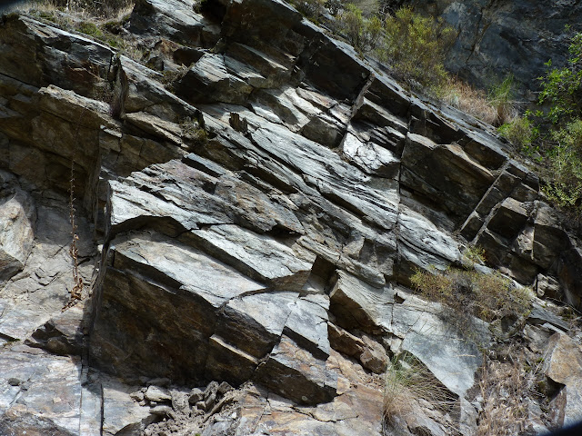
Below is a photo of a blocky, fractured outcrop of metamorphic rocks of the
Riggins Complex north of the town of Riggins.
It would be very difficult to tell whether these mica schists were
originally sedimentary or igneous rocks when they were deposited in the South
Pacific Ocean 250 million years ago.
.jpg)
The photo below is a close-up of the same outcrop of Riggins Complex
schists. Note the way the sunshine on
the rocks gives them a “sheen” caused by the planar alignment of the flat mica
sheets that make up the schist.
.jpg)
After climbing a very long hill on US 95 northwest of White Bird, ID, we
encountered another abrupt change from the rocks of the island arc back into
the Columbia Plateau Basalts. It will
be interesting to see if the island arc terranes of the Okanagan Valley of
central Washington and southern British Columbia have as abrupt contacts with
the surrounding rocks as those of Idaho.
And now, if you happen to be driving home from Alaska via US 95 from Coeur
d’Alene to Boise, you will know exactly when you leave North America and enter
the “South Pacific”!
Next time: Glaciation in the Coeur d’Alene to Grand Coulee region has immensely
modified the Columbia Plateau basalt surface in east-central Washington State.

.jpg)
No comments:
Post a Comment